iTwin Capture Modeler
Give life to your field surveys in usable 3D models
iTwin Capture Modeler turns your photos and scans into accurate and usable 3D models. Quickly generate meshes, dot clouds and orthophotos to create reliable digital twins. Accelerate your infrastructure projects by modelling directly from the field.
iTwin Capture Modeler: enrich your digital twins with accurate data
Turn reality into usable data
To improve design, construction, operation and collaboration, integrate a real-world digital context into your projects to quickly address infrastructure challenges and make informed decisions.
iTwin Capture Modeler allows you to automatically generate multi-resolution 3D models, at any scale and with great precision.
Capture
Use the most accurate and versatile realistic data capture solutions to provide a digital context essential to design, engineering, construction and operation.
Manage and Share
Provide stakeholders with instant access to real data, transformed into usable information. Ensure that they have the right information at the right time for more informed and timely decisions.
Analyse and deliver
Convert real data into concrete information, enabling data-based decisions, through artificial intelligence and machine learning. Use this data to power your digital twins.
iTwin Capture Modeler
Advanced visualization of reality meshes: view and operate meshes of any size with Bentley's Viewer of Twin Capture Modeler.
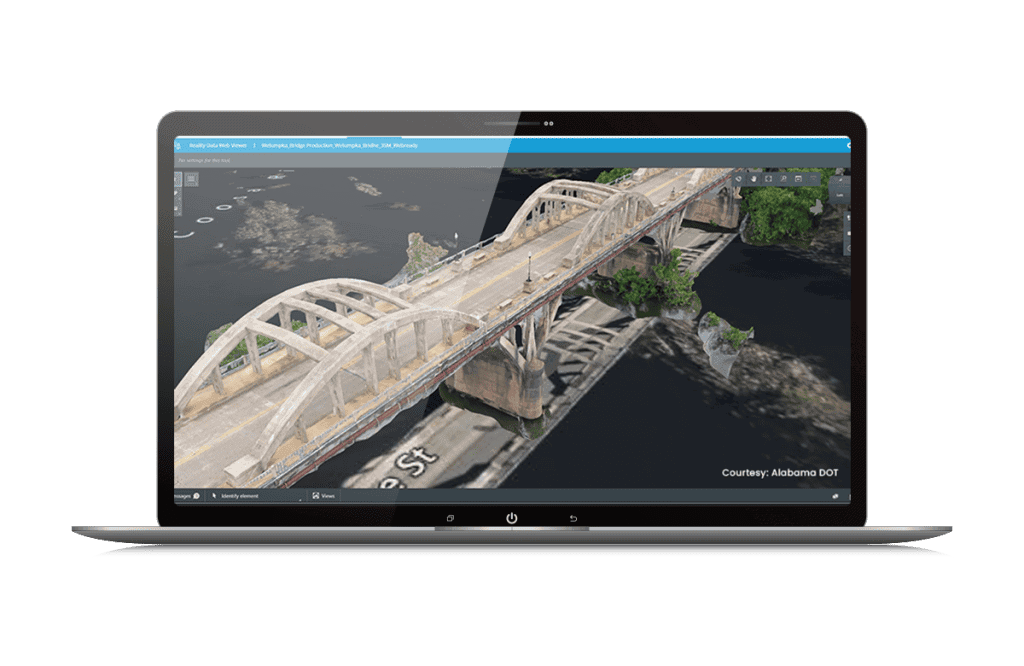
iTwin Capture Modeler is a powerful and versatile 3D modeling software designed to generate reality data that provides a precise digital context to workflows for design, engineering, construction and operation. It allows to produce quickly and with unparalleled quality meshes of reality, on any scale, from photographs or clouds of LiDAR points.
Available in two versions – iTwin Capture Modeler and iTwin Capture Modeler Center – it adapts to all needs. The Center version makes it possible to create an unlimited number of aggregates, thus facilitating the rapid processing of large-scale projects, up to the modelling of entire cities.
Enter any data
Turn simple photographs and/or LiDAR point clouds into ultra-detailed 3D models of your existing conditions.
Deliver on time
Enjoy the fastest processing speed to date and optimize parallel processing by creating an aggregate using up to two engines simultaneously.
Measures
Take advantage of highly accurate analysis and measurement tools for your reality meshes.
Enable online distribution
Generate multi-resolution meshes, made up of billions of triangles, optimized for streaming and web publishing.
Generate accurate reality data
Create realistic multi-resolution meshes, 2.5D digital surface models, accurate orthophotos and point clouds, with different levels of precision.
Retouches
Quickly refine your realistic meshes with intuitive and easy-to-use tools.
Take advantage of interoperable formats
Create 3D models in various GIS formats and integrate them easily into all your workflows
Automate the classification by object type and region
Use 3D machine learning technology to automatically detect, locate and classify your data from reality.
User Word
Through these data collection methods, the government could achieve potential annual savings of at least S$5 million, with an update cycle every two years.
— Hui Ying Teo, Senior Surveyor, Singapore Land Authority
Licensing Options
Annual rental
The simple and efficient way to use software over a fixed period of 12 months. The license is associated with the user and can be used on several posts (but not simultaneously).
The annual subscription includes a number of "keys" that can be exchanged for training or accompaniment (mentoring).
Perpetual licence
A perpetual license is a unique purchase, it can be accompanied by an annual maintenance contract called SELECT. The latter assures you that your software is always up to date, 7 days a week and 24 hours a day support and allows for the buoyancy of licenses among other services.
The SELECT contract offers maintenance for your perpetual licenses including various benefits:
- Floating licences
- Software updates
- Balancing the licensing portfolio
- Technical assistance 24/7, 365j/365
- CONNECT services