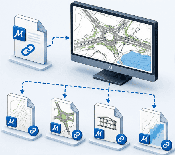
Attaching an external file to a design project is a daily gesture, as well in MicroStation Only in AutoCAD. But behind this seemingly identical gesture are two features with very different limits. AutoCAD talks about « Xref » (external reference) to designate the insertion of an external DWG file, and treats images or cloud points as separate objects, with separate commands. MicroStation brings together these different attachments under the common term d « attachment », but each type — vectorial, raster, dot cloud, reality mesh — has its own dedicated tool. This article focuses on vector references (DGN, DWG), the most common use case and the direct counterpart of the Xrefs AutoCAD; the other three types of attachment are mentioned only for memory purposes.
Xref AutoCAD: an external reference, several partitioned commands
In AutoCAD, the term « Xref » Historically, one thing is the attachment of an external DWG file via the XATTACH command. Other types of external data follow separate logics: a raster image attaches with IMAGEATTACH, a cloud of points with POINTCLOUDATTACH. These objects certainly appear together in the palette « External references »but they do not share the same properties, the same scaling mechanisms, or the same geolocation management. Another structural limit: the DWG format supports only one design space per file (l « Subject matter »), supplemented by layouts (spaces « Paper »). A Xref can only refer to space « Subject matter » default — It is impossible to point to a subset organized into separate models within the same file, as is the case with DGN files.
MicroStation: the vector reference, at the heart of this article
MicroStation means « reference » Four distinct attachment types: vector files (DGN, DWG, DXF, IFC, SKP, SHP and a multitude of other formats), raster images (more than 40 supported formats), dot clouds (almost 20 available formats) and reality meshes. These four attachment types with specific characteristics are managed by specific dialog boxes with settings specific to the nature of the data. What they share, on the other hand, are the same substantive principles, detailed below in this article: scaling up based on work units, and georeferencing consistent when files carry a coordinate system. It should be noted that the DGN format allows for the creation of several spaces « Subject matter », and, on the other hand, allows to attach any space in reference, whether it is located in another file or in the current file. The current space can also attach itself which is very convenient to place in its plan a detail on a more suitable scale. This latter possibility is simply not possible in AutoCAD (cyclic reference).
Memory: images, dot clouds and reality meshes
The images raster — These are usually scanned plans, orthophotos, cadastral backgrounds. They attach via a dedicated manager, with the possibility of projecting, cropping and format conversion directly from the tool.
Clouds of points — from a laser scanner or photogrammetric modelling, attach via a dedicated tool; MicroStation manages much larger point volumetrics than AutoCAD, a real asset on large field surveys.
Reality meshes — products for example with iTwinCapture Modeler — attach via a tool dedicated to mesh formats (3MX, 3SM...) and overlap with the model thanks to a common georeferencing.
A reference element remains accessible individually
In AutoCAD, an Xref is treated as a block: all its contents form a single object inserted in the host file. Cannot select or copy an isolated element contained in the Xref without specific operations — activate the existing edition (REFEDIT) by adding the element to the « working set », or bind (bind) then explode the reference to extract its geometry. This technique may be binding if the reference is superimposed on data from the main file. In MicroStation, each element of a reference remains individually selectable, as if it were part of the active file. A projector can copy a specific element of a reference directly into the master file, without intermediate step or block manipulation — a saving of concrete time on recovery or reuse of details between projects.
Enable a reference to edit without leaving the main file
Another practical difference: when the referenced file is accessible in read/write, MicroStation allows to make it temporarily « active » directly from the master file. The user then intervenes on a reference element — point correction, adjustment of a plot — without having to open the file separately, find the right level (calk) or zoom manually at the place concerned. Once the change has been made, simply return to the main file; changes are saved in the referenced file. This mechanism saves real time on point fixes within large file assemblages.
Work units: automatic and reliable scaling of references
We were recently detailing why 1 meter never becomes 1 centimeter in MicroStation. This unit architecture finds its full value at the time of attachment of a reference: MicroStation automatically calculates the scale ratio between the units of the attaching file and those of the attached file. If the master file works in meters and the file attached in millimeters, the reference appears instantly on the right scale, without any manual intervention — This is the principle of « True size » (True Scale). In AutoCAD, this behavior depends entirely on the INSUNITS parameter defined in each of the two files. If either is absent, inconsistent or settled on « Unitless », automatic conversion fails and manual scaling — therefore subject to human error — becomes necessary. On projects where files come from different partners, subcontractors or administrations, this fragility is a recurring source of repetition.
Georeferencing: the true strength of MicroStation
This is probably the most significant difference between the two approaches. As soon as the attaching file and The attached file each has a defined geographic coordinate system (GCS), MicroStation can reproject the reference on the fly, even if the two coordinate systems are different. Two methods are available: a rapid transformation (AEC Transform), adapted to reduced geographic rights-of-way, and a complete, more precise reprojection recommended on large rights-of-way where deformations related to mapping projecting become sensitive. This projection is calculated at the display and never alters the referenced file: it is reversible and specific to each attachment. In concrete terms, a DGN file built in French projection RGF 93 CC48 can be attached correctly to the right scale and position in a master file working in UTM WGS84 — without random recalibration, without script, without manual scaling. For activities in various regions of the world, where local geodetic reference systems differ from country to country — or are multiple within the same country — This capacity changes the situation in practice. In AutoCAD, option « Locate using Geographic Data » when attaching a Xref requires that Two files use the Same system of geographical coordinates (*). If this is not the case, only the geomarker is correctly transformed: the rest of the geometry can be mispositioned. The software reports inconsistency but does not prevent attachment, leaving the user the responsibility to detect — or to miss — Error. (*) However, it is possible to use a specific extension such as AutoCAD Map to improve the projection functionality.
Other technical advantages: access roads, interlocking and cutting
Beyond units and georeferencing, several structural differences reinforce the reliability of MicroStation vector references in a multi-site professional context: Storage of access path. MicroStation offers three storage modes from the path to the attached file: no path, relative path, or path based on a configuration variable. This last mode is particularly valuable in a study office working on several posts or sites: simply point the variable to the right project folder so that all references are found, without ever changing the files themselves. AutoCAD, for its part, proposes only the relative path or the absolute path. Cross references. MicroStation allows you to precisely adjust the depth of the interface (Live Nesting) and make the level, colour or style overloads persist through several reference levels. In AutoCAD, the VISRETAIN variable keeps layer overloads for directly attached Xrefs, but these settings do not systematically spread to embedded Xrefs inside other Xrefs — a point of vigilance in multi-level assemblies. Cuts (clips). A MicroStation reference retains its cutting limits (clip boundary) natively and permanently in the DGN file, including for nested references. Conversely, saving a file in DWG format does not preserve the cuts applied to Xrefs: they are lost during conversion.
Comparison table: 10 key points on reference files
Criteria
MicroStation
AutoCAD
Access to reference elements
Each item remains selectable and copyable individually
Xref treated as a block; copying an isolated element requires REFEDIT or bind/explode
Edit reference from master file
Temporary activation in read/write, without opening the file separately
Editing in place via REFEDIT, with manual working set management
Internal models of the attached file
Multiple object (design) space per DGN file, target space chosen freely
Only one default object space per DWG file; IXref refers only to this model
Scaled at attachment
Automatic calculation of the scale ratio according to the working units of the two spaces (attaching and attaching)
Depends on the INSUNITS setting of both files; risk of wrong scale if absent or inconsistent
Georeferencing
Reprojection on the fly between systems of different coordinates, if both spaces have a defined GCS
Requires an identical coordinate system on both files; or partial alignment only
Storage of access path
No path, relative path, or configuration variable (multi-post portability)
Depends on the specific settings of each connected third party software
Start well with references in MicroStation
Migrating from AutoCAD means rethinking your reflexes around the Xrefs: teams generally find with relief that a reference element is copied as freely as an element in the active file, that scaled references are part of the past and that changes in their presentation are handled in an extremely fine way without modification of the file itself. beCAD, Bentley Systems partner, supports this transition with a dedicated course for migrate fromAutoCAD to MicroStation and also through MicroStation training which covers in depth the management of references, units and geolocation, with practical cases from your own projects.
Frequently Asked Questions
What is a reference file in MicroStation?
It's an external file — most often a DGN or DWG — attached to a design model without being physically part of it. It remains visible, positioned and scaled automatically, without ever being merged into the master file. Free positioning and/or manual ladders are, of course, always possible.
Can MicroStation refer to an AutoCAD DWG file?
Yes. A DWG file (any version!) can be attached as a vector reference in MicroStation exactly as a DGN file, with the same dialog box and the same scale and geolocation settings.
Can one copy an element contained in a MicroStation reference?
Yes. Each element of a reference, including if it is a DWG, remains individually selectable in MicroStation, allowing it to be copied directly to the master file. In AutoCAD, a Xref being treated as a block, this operation requires going through the current edition (REFEDIT) or binding and then blowing up the reference.
Can you change the content of a reference without opening the file separately?
Yes, provided that the referenced file is accessible in read/write: MicroStation allows you to temporarily activate from the master file, to make a correction, and then to return to the main file without manual browsing step.
Does georeferencing work automatically between two files with different coordinate systems?
In MicroStation, yes, provided that both files (attach and attach) each have a defined geographic coordinate system: the projection is then done on the fly. In AutoCAD, georeferenced attachment requires both files to share the same coordinate system; in the case of different systems, only the geographical reference point is properly transformed.
In conclusion
Xref or reference: vocabulary is similar, but architecture behind it differs profoundly. By keeping each individually accessible element, allowing direct editing of a file referenced from the master file, and applying consistent principles of scaling and georeferencing, MicroStation Structurally reduces the risks of error and time losses for large multi-file and multi-stakeholder projects. To evaluate how to secure the management of your reference files with Bentley Systems solutions, the beCAD team remains at your disposal.
We use cookies to guarantee you the best experience on our website. If you continue to use this site, we will assume that you are satisfied with it.